Tropical News

Alenga and Tropical Cyclone 02S pose no threat to land, yet the remnants of Alenga may bring some rough surf to the western coast of Australia.

Tuesday, December 6, 2011

Alenga and Two-S not bothering anyone

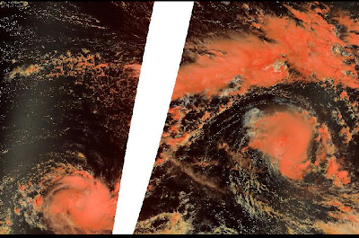
Figure 1: Image of Tropical Storm Alenga (middle right) and Tropical Storm 02S (bottom left).

The first two tropical cyclones of the Southern Hemisphere tropical season have formed in the Southwest Indian Ocean region. Alenga gained a name yesterday and was destined to become a Category 2 equivalent cyclone. However shear and cooler waters prevented that and Alenga has now started to weaken. Alenga is a 50mph tropical cyclone and should move into the Australian region sometime tonight or tomorrow. It is unlikely that Alenga will survive long enough to impact Australia as a significant cyclone.

The other area of interest is our second tropical cyclone of the Southern Hemisphere: TC 02S. The Joint Typhoon Warning Center is observing this as a tropical storm, while Meteo France (MF) is only observing this as a tropical depression. The official forecast from JTWC keeps 02S steady at 40mph, while MF strengthens it to gain a name. The track for now is for the system to continue a westward movement until dissipation. The next name is Benilde.

Other than a worthless tropical depression that formed in the Western Pacific, the rest of the tropics have been quiet.

Matt

*Image credit to NASA

Saturday, November 26, 2011

Tropical Cyclone Five-A moving away from the coast of India

A new tropical cyclone over the Arabian Sea is causing havoc to portions of South India tonight. The cyclone has already caused three fishermen to go missing, as well as about 1500 homes in Sri Lanka being damaged. This system means business! Right now, the Joint Typhoon Warning Center is classifying this system as a tropical storm, however the India Meteorological Department is assessing this as a deep depression. This is why 05A has not gained a name yet. However, they continue to insist that this system will become a cyclonic storm thus gaining the name Thane. The JTWC also continues to insist that conditions will only be marginal for development, thus making strengthening difficult for the system. They only expect 05A to reach a peak of about 60mph.

An area of broad low pressure in the Southwest Indian Ocean continues to be stationary and struggle to develop. This system, designated 96S by the JTWC, has not moved in the past 12 hours. With vertical wind shear of about 30 knots impacting the system, mostly from the outflow of Tropical Cyclone 05A, any strengthening will be difficult. However, this system has shown signs of fighting for survival. The first name on the list is Alenga if it were to in fact to strengthen enough into such a storm.


Figure 1: Tropical Cyclone Five-A is shown to the west of India, and 96S is shown to the northeast of Madagascar.

That's all for today!
Matt

Wednesday, November 16, 2011

Possible late season activity for both basins?

Computer models are continuing to insist that we will have tropical storms in both basins by the end of the month. An area of disturbed weather (Invest 90E) has been designated in the Eastern Pacific and the National Hurricane Center is currently giving this system a low chance (10%) of developing in the next 48 hours. Tropical Storms this late in the season is very rare and there have only been 3 on record to have formed this late in the Eastern Pacific Hurricane Season: an unnamed tropical storm on November 27, 1951, Tropical Storm Sharon on November 27, 1971, and Hurricane Winnie on December 5, 1983. None of these storms affected land, and our potential Eastern Pacific Tropical Storm's track is uncertain.

Figure 1: My graphic on our newly formed Invest 90E.

In the Atlantic, the models are back on board with tropical/subtropical development northeast of the Atlantic. The origins would likely be non-tropical and the system would likely meander for a couple of days. This is similar to how Tropical Storm Sean developed.

So it's extremely possible that we get both Tropical Storm Kenneth (EPAC) and Tropical Storm Tammy (ATL) between now and next week. It's even possible that Kenneth could become a hurricane, if conditions improve for development.

Our first tropical disturbance of the 2011-12 South Pacific Season formed the other day and was extremely large in nature, almost monsoonal. This storm dumped a lot of rainfall on the island of Fiji. The Joint Typhoon Warning Center, at one time, gave this a Medium chance of development. However, the system was just too large, and wind shear was just too strong for this system to actually gain a name. We are in a La NiƱa event which typically means a more active season for both the South Pacific and the Australian Region. Activity is usually suppressed in the Southwest Indian Ocean during this event.

I'll have more updates as we learn more about our possible developments.
Matt

Friday, November 11, 2011

Sean merges with a front

Sean is now post-tropical as he has merged with a cold front. The National Hurricane Center has written their last advisory on the system. Bermuda did in fact get tropical storm force winds from Sean. Top winds were estimated to be around 45mph on the island. Sean indirectly caused one death in Florida due to rip currents.

Figure 1: Sean as it merged with a front.

There are no other areas to talk about currently, but the computer models are picking up on possible tropical development in the mid-Atlantic in about a week or so. They suspect a non-tropical low may gain some subtropical or tropical characteristics, similar to what happened with Sean. If any non-tropical low were to become subtropical, they name they would gain would be Tammy.

The other basins are quiet!
Matt

Thursday, November 10, 2011

Sean has peaked

Our only area of interest in the tropics today is Tropical Storm Sean. Sean has reached his peak as a 65mph tropical storm and should not be able to strengthen to a hurricane due to cooler waters. Bermuda is still under a Tropical Storm Warning due to Sean's wind field being extremely large. The forecast shows that Sean will become extratropical sometime in the next day or two.

Figure 1: Rainbow IR picture of Sean.

Figure 2: Projected Path of Sean

Some of the computer models are showing development in two different places. The GFS (American) Model has been off and on with subtropical development in the mid-Atlantic in about a week or so. Other models, like the NOGAPS and CMC, are forecasting development in the Southwestern Caribbean. These are typical hotspots for November, so I wouldn't completely write off the 2011 Atlantic Hurricane Season just yet.

The Eastern, Central, Western, and Southern Pacific Basins are quiet.

The North and Southwest Indian Ocean basins are quiet.

The Australian Region is quiet as well.

A short post for a boring day!
Matt

Wednesday, November 9, 2011

Sean almost a hurricane

Tropical Storm Sean has gradually gotten better organized today. Infrared and Visible Imagery show that an eye may be trying to form. This may be a sign that Sean may be close to hurricane strength. Winds are already close to it and only 9mph shy of becoming a Category 1 hurricane. We'll see what the next few days hold.

The projected path for Sean continues the motion to the north with a turn to the northeast sometime tomorrow. During that time, the National Hurricane Center thinks that Sean could reach minimal Category 1 strength but quickly weaken. Due to the large wind field of the system and the proximity to Bermuda, the Bermuda Weather Service has issued a Tropical Storm Warning for the island. If Sean becomes a stronger hurricane than expected, it wouldn't be out of the question that a Hurricane Watch or Warning be issued. However this seems highly unlikely at the moment.

Tropical Cyclone Four-A lost organization today and the Joint Typhoon Warning Center wrote their last advisory on the system.

The Australian Region and South Pacific basins are quiet today and there are no areas of concern.

The Southwest Indian Ocean Cyclone Season starts November 15.

That's all for today.
Matt

Tuesday, November 8, 2011

Tropical Storm Sean; Rare Mediterranean cyclone; Four-A churning

Tropical Storm Sean is the main topic for the tropics today. Since it's November, the tropics really wind down. Every now and then we'll get a tropical system such as Tropical Storm Sean, the nineteenth tropical cyclone of the 2011 tropical season. The formation of Sean brings us in 6th place for the most active season on record. The origins of Sean can be tracked back from a non-tropical low that moved off the Carolina coastline. After meandering and moving southward, the low acquired subtropical characteristics and become Subtropical Storm Sean. Sean acquired tropical characteristics and became fully tropical this afternoon.

Sean is currently meandering to the southwest of Bermuda. There may be a slow drift to the west or west-northwest, but Sean (as of the 7pm EST advisory) is currently stationary. Sean is not expected to stay there for long. A trough that brought severe weather and tornadoes to Oklahoma yesterday, is expected to come a long and pick Sean up and scoot him very quickly out to sea. When the trough does come and pick Sean up, the island of Bermuda may be directly impacted. As a result, the National Weather Service in Bermuda has issued a Tropical Storm Watch for the island.

A hybrid low pressure system was dubbed 99L on the Navy Site for Tropical Cyclones yesterday in the Mediterranean Sea. Named "Rolf" by the German Weather Service, this system had acquired tropical characteristics. This marked the first time in history a tropical system had formed and been named in the sea. Other such happenings have occurred such as in 1995 where a hurricane like storm formed between Greece and Italy. It is highly likely that this basin along with other unusual formation spots (i.e. the South Atlantic Ocean) will see an increased number of activity of tropical systems.

Another tropical cyclone has formed in the Arabian Sea. November is a secondary peak of the North Indian Ocean and it has made itself known over the past week. This is the second system to form in the Arabian Sea this month. Tropical Cyclone Four-A is currently drifting northward, however a westerly and southwesterly component is expected.

Until the next post,
See ya!
Matt

Sunday, October 30, 2011

Quiet for now

All is quiet!! Rina made landfall close to Cozumel a couple of days ago, but considerably weaker than previously forecasted. Rina made landfall as a tropical storm, and weakened shortly after entering the Yucatan Channel. She degenerated into a remnant low pressure soon thereafter.

The Atlantic Season is coming to a close, as we only have one more month to go. November typically brings little to no activity for the Atlantic. I think we may see one or two more disturbances form with one possibly becoming a tropical system possibly gaining the name Sean. Forecasters were considerably hyper on their forecasts this year. October was not as promising as it seems it would be. Two disturbances possibly should have been classified as subtropical or tropical systems, but they were not classified.

As our attention slows down on the Atlantic, Eastern Pacific, and Central Pacific, we start to focus our attention to the southern hemisphere. This is a La NiƱa year, so expect to see less activity in the Southwest Indian Ocean Basin, and more activity in the South Pacific and Australian regions. We also focus our attention to the North Indian Ocean for the month of November mainly because this is a secondary peak for their year round season, their first peak is typically in May.

That's all for today.
Matt

Monday, October 24, 2011

Rina forms and rapidly strengthens; 97L a threat as well

Hurricane Rina is the main topic this afternoon. About 28 hours ago, Tropical Depression Eighteen was declared from Invest 96L as it had gained enough organization to be declared a tropical depression. Six hours later, Eighteen was named 'Rina.' This name replaced Rita from 2005. Twenty-one hours after classification, Rina had rapidly strengthened to a hurricane thanks to Hurricane Hunter observations. There are no advisories at this time, but interests along the coast of Belize and the Yucatan should monitor the progress of Rina. A Hurricane Watch should be issued tomorrow afternoon.

Latest microwave imagery shows that Rina has an open eyewall to the northeast, but it is slowly closing off. When it does, rapid intensification may occur again. Rina is expected to become a major hurricane soon per the National Hurricane Center. The forecast remains fairly uncertain and it currently has Rina making landfall on the coast of the Yucatan in about four days with a sharp turn to the east thereafter.

A broad area of low pressure (Invest 97L) is bringing squally weather to the ABC Islands tonight. Satellite shows a disorganized system, but models show some development of this system. The National Hurricane Center is currently giving this system a 20% chance to develop in the next 48 hours. Conditions are only marginally favorable for development and cyclogenesis will be slow to occur. The NOGAPS model shows that 97L which reach a moist environment between Jamaica and Nicaragua, forming it into a tropical depression. This scenario may happen and it seems like a logical one. This system could be a powerful storm for the island of Cuba and possibly Jamaica as it makes a turn to the north and north-northeast. I will continue to monitor this system for further development.

Matt

Friday, October 21, 2011

Tale of Two Invests: 96L and 97L

I apologize for not updating this blog during Hurricanes Jova and Irwin along with two possible developments in the Atlantic. School work has been the main priority here lately.

Today there is an invest in the Southwestern Caribbean that is trying to get it's act together. Invest 96L doesn't have any signs of a surface circulation at the moment, but surface pressures are falling in the area. This system is also currently drifting to the south, but a more northerly motion is expected soon. Forecaster Avila had strong wording in his 2pm Tropical Weather Outlook stating that there is a 'likelihood that a tropical depression could form over the weekend'. The NHC is giving this system a 60% chance of developing in the next 48 hours. Eventually, this system might affect Florida and Cuba in about a week or so. This system will closely be monitored for any type of sudden development.

A pop up area of broad low pressure to the east of South America is trying to get its act together this afternoon. The NHC has named this Invest 97L. Forecaster Avila has 'up-ed' the chances of development to a 20% chance of development. Models aren't it very good agreement, but a slow movement to the north-northwest is likely over the next couple days with a gradual turn to the west-northwest and eventually the west. This system has little time to develop before it starts to feel the affects of the outflow from a possible tropical cyclone: Invest 96L.

The next two names on the list are Rina and Sean.
Matt

Friday, October 7, 2011

No post

There will be no post tomorrow because I will be out of town all day and will not return until extremely late. Therefore, there won't be a post. I'll try to have one Sunday.

Thanks!
Matt

Hurricane Philippe now starting to weaken; Jova and Irwin eye Mexico

Hurricane Philippe is likely no longer a hurricane
on this Friday afternoon. With a center of circulation exposed to view and heavy wind shear doing the trick, Philippe will most likely be a tropical storm at the next advisory from the National Hurricane Center at 5pm EDT. Philippe shouldn't cause any trouble to any land areas.

The stationary front has stalled and a shortwave trough is now starting to amplify itself. Showers and thunderstorms are on the increase around Florida, Cuba, and the Bahamas. Low pressure is expected to form late this weekend, however any development will be slow to occur. With the subtropical jet stream tearing into the Caribbean, and possible development happening north of the jet stream, any development will be subtropical in nature. Many models develop the system and have it going many different places. However, I'm leaning towards the GFS (American) Model today. The Model takes the storm up to the east of Florida and takes it northward into Georgia and South Carolina. I think this may make landfall a little bit farther north, similar to where Hurricane Irene made landfall just a short time ago. You can expect heavy rainfall and winds to be the primary threat for the east coast. Rip currents and beach erosion are threats as well.

After the subtropical development is through, and dissipates, our attention will be turned toward the Caribbean for TRUE tropical development. We've been talking about this scenario now since the beginning of September, and the time has SLOWLY marched its way forward. With a hurricane and a tropical storm possibly becoming a hurricane soon in the Eastern Pacific, that same energy will make its way toward the Caribbean. Any system to form will be broad in nature, but it will be a heavy rain producer. The Yucatan Peninsula, Belize, Cuba, Florida, and the Cayman Islands need to pay attention to this system, as it may strengthen into a deep system.

Hurricane Irwin is a Category 1 hurricane this afternoon, with satellite estimates a little higher since the 11am EDT advisory. The projected path for Irwin tells a tale of an erratic movement. The track bends Irwin to the east by Saturday and continues to motion until it reaches the coast of Mexico. Irwin can strengthen possibly to a major hurricane before dealing with wind shear. Irwin is not an immediate threat to Mexico right now.

Tropical Storm Jova this afternoon is increasing in intensity and it poses a larger threat to Mexico. This will be their first system to deal with, before Irwin. Jova is expected to make a turn to the north sometime Sunday with a turn to the northeast on Monday. Jova is expected to strengthen until landfall possibly as a major hurricane. We have not seen this happen since I believe Hurricane Kenna in 2002 which struck the coastline as a Category 5 hurricane. Thankfully, Jova should not be that strong. Jova is not an immediate threat to Mexico, but in time it will be.

Another invest in the Eastern Pacific, 99E is showing signs of organization this afternoon. This system is most likely going to become a tropical depression or storm in the next couple of days as well. It's most likely going to gain the name Kenneth in the process. This storm will move northeastward into the Gulf of Tehuantepec and either make landfall on the coast of Mexico, Guatemala, or El Salvador. This system will continue to be monitored.

That's all for today.
Matt

*On the second graphic, the storm on the left is Hurricane Irwin and the storm on the right is Jova.
**All image credit goes to NOAA.
Thursday, October 6, 2011

Philippe becomes a hurricane; Irwin and Jova have evil plans

Philippe is now a hurricane with winds of 85mph. The National Hurricane Center, as of 5pm, has increased the wind speed of the hurricane, however they stated in their discussion (Discussion #51) that the intensity may be a bit conservative. Philippe definitely has an impressive look on satellite and it is possible that Philippe peaks at a Category 2 hurricane before further weakening. Philippe is no hazard to any land masses.

Models are still forecasting subtropical development off the coast of Florida from the stationary cold front that is already off the coast. Meteorologists and Huricanologists are comparing this storm to the Subtropical Storm of 1974, which brought heavy beach erosion, rip currents, gales, and heavy rains to the coast of Florida. With the MJO (a cycle that brings rising motion to the Atlantic allowing thunderstorms to form) coming into our area soon, it will only increase the percentages of a subtropical storm actually forming. We could very well be talking about Subtropical Storm Rina early next week.

We have two tropical storms in the Eastern Pacific and both pose a significant threat to the coast of Mexico, preferably the Cabo Corrientes, Zihuatanejo, Puerto Vallarta, and Manzanillo areas. Tropical Storm Jova poses the earliest threat. The just named storm, Jova has winds of 40mph, and is currently expected to come ashore as a strong Category 2 hurricane sometime Monday Night or Tuesday Afternoon. Our next storm is Tropical Storm Irwin, a stronger tropical storm with winds of 60mph. Irwin will also pose a threat to the same areas, however, it is too early to tell when the storm may affect the areas. Tropical Storm Watches will be needed sometime over the weekend for Tropical Storm Jova.

Just recently, the Eastern Pacific went from dead, to very active. This is due to the MJO coming into the area. This same MJO will enter the Atlantic and will provide a better environment for strengthening.

Matt

Wednesday, October 5, 2011

Philippe still around; Two new Eastern Pacific areas

Tropical Storm Philippe is still around as a 65mph tropical storm. Convection is still displaced to the south of the center of circulation due to strong wind shear affecting him from the north. Philippe is now moving to the north ever so slowly at about 7mph, but should turn to the northeast and Philippe has the potential to peak as a minimal category 1 hurricane tomorrow afternoon. Shortly thereafter, wind shear should increase and Philippe will combine with a frontal boundary and become post-tropical.

Subtropical Development seems to be the new hot topic in the tropics. This weekend, we will need to watch the coast of Florida, Cuba, and the Bahamas for possible subtropical development. A stationary frontal boundary is stalled out off the coast of Florida and with a high pressure to the north, and low pressure to the south, a trough split should occur which will allow any mischief to start brewing. The subtropical jet stream is located over the Caribbean Sea currently, shearing the area. With all of these things coming into play, it is logical that there will be cold air aloft and subtropical genesis may occur. This storm will be watched for possible strengthening, and it may impact the East Coast starting Tuesday into Wednesday. By that time, the GFS (American Computer Model) is forecasting that there is a tropical storm approaching, if not already at, hurricane strength. What you can count on is for stormy weather and gale force winds across the area through the weekend into early next week. The next name on the list is Rina.

In the Eastern Pacific, Invests 97L and 98L have taken shape and are rapidly getting organized. It is very possible that we could be talking about Tropical Depressions Ten-E and Eleven-E tomorrow afternoon. Thankfully these systems will be no threat to land. The next names on the list are Irwin and Jova.

Super Typhoon Nalgae has dissipated to the east of Vinh, Vietnam. Expect heavy rainfall over the next couple of days, even though it is no longer a tropical system.

Sorry for not having a post yesterday. I suddenly became very busy.
Matt

Monday, October 3, 2011

No more Ophelia!

After a life cycle, then regeneration, then a whopping Category 4 hurricane, Ophelia is gone for good. Ophelia struck the Avalon Peninsula this morning and caused little to no damage reported so far. Most of the heavy winds were offshore, so therefore the island and peninsula only got just a little bit of rain.

Tropical Storm Philippe is still in the Atlantic. This system has been a nuisance in resisting to dissipate in the spite of destructive wind shear. Philippe is currently moving toward the west-southwest and will continue to do so until the cold front that swept the east coast recently picks Philippe up and makes a sharp turn to the northeast. Philippe has surprised us all, so it won't be out of the question that Philippe makes hurricane status in the next couple days. It'll be interesting to see how strong Philippe finally does get.

We had a surprise invest today. Just as fast as it was declared, it was deactivated. Invest 92L formed from an extratropical storm to the northeast of the Azores. It has been moving southwest and is making a turn toward the west-northwest. If this system continues to do so, it may encounter more favorable conditions. In the next couple of days, it'll be interesting to see if we can get one of those subtropical/tropical systems that form from non-tropical entities. The last storm to do so was Tropical Storm Grace in 2009. Grace peaked as a strong tropical storm and also set a record for the farthest northeast a storm has formed. This system could be similar to Tropical Storm Laura in 2008. It's a wait and tell situation.

Models continue to indicate that sometime next week we will need to pay close attention to the Caribbean for possible development. However, a new entity has sparked interest on the models. With the pressure gradient between high pressure over the Eastern CONUS (Continental United States) and the low pressure in the Caribbean, the gradient might be enough to support subtropical development of a trough split. This could be one of those surprise storms. Any such storm to form will be rather large, and windy. This could possibly be Subtropical Storm Rina since models are forecasting this storm to form before the real tropical one in the Caribbean. In any situation, Florida will need to monitor this storm for possible very rainy weather and very strong winds, potentially up to gale force.

Tropical Storm Nalgae has left his mark on the country of the Philippines. Nalgae is now a disorganized storm with winds only at 50mph. Nalgae is expected to remain this way as it makes a second landfall on the country of Vietnam.

Matt

Saturday, October 1, 2011

Ophelia now a Category Four hurricane; Nalgae weakening in Nesat's wake

Hurricane Ophelia is a Category 4 hurricane tonight. Ophelia has surprised everyone by her intensifica
tion under somewhat hostile conditions. The eye has warmed and is surprisingly clear. There is nothing really inhibiting Ophelia from strengthening and has a shot at becoming the strongest storm thus far. The strongest (pressure wise) have been Hurricane Irene and (wind wise) Katia. Ophelia is currently about 140 miles east of Bermuda. Bermuda has been spared from her wrath. However, Bermuda has gotten some showers and thunderstorms from Ophelia. The Weather Service in Bermuda has discontinued the Tropical Storm Watch for the island, however the Environment of Canada has issued a Tropical Storm Watch for the Avalon Peninsula of Newfoundland. Since Ophelia has become much more stronger than previously forecasted, Newfoundland could get a hurricane from Ophelia. A tropical storm warning and hurricane watch is most likely expected sometime tomorrow.

Philippe has held on to life the past few days. He is currently under about 35-40kts of wind shear, mainly from the outflow of Hurricane Ophelia, yet he has current winds of 65mp
h which is up from the 50mph earlier this afternoon. Philippe is expected to bend westward with a turn to the northeast expected by day four.

Models continue to predict tropical cyclone development will happen sometime late next week. The Madden-Julian Oscillation, a weather phenomena which brings rising motion to ocean waters allowing thunderstorms to form, is coming into our area soon. Any storm to form would either curve out into Cuba, Florida, and the Bahamas or bend westward into the Yucatan Peninsula and Belize. I will continue to monitor this situation as time progresses forward.

Typhoon Nalgae rapidly intensified last night to a super typhoon with winds of 150mph before
landfall on the island of Luzon. This was probably one of the worst case scenarios. Heavy rainfall has fallen across the island and Nalgae is under the cool wake left behind by Typhoon Nesat. Nalgae is expected to slowly weaken and follow a similar path to Nesat, however it will be a little farther south. A Vietnamese landfall near Hue is likely. Nalgae should be a strong tropical storm or weak Category 1 typhoon at landfall.

Matt
(Next post will be Monday)

No post

There will not be an informational post today, unless I do it later tonight. I have come across some work that I HAVE to get finished. So there may be a post tonight around 8pm or 9pm*.

If there is not a post today, there will be a post either tomorrow or Monday.
Matt

*All times are EDT

Friday, September 30, 2011

Major Hurricane Ophelia; Nalgae about to slam the Philippines


Hurricane Ophelia is now a Category Three hurricane as opposed to the Category One hurricane that it was yesterday at this time. Despite the wind shear and dry air, Ophelia has remarkably been able to fight it off to tighten its core to become the third major hurricane of the 2011 Atlantic Hurricane Season. Additional strengthening is possible, but not anticipated as it moves into an unfavorable environment for strengthening. Bermuda is currently under a Tropical Storm Watch and that may be changed to a Tropical Storm Warning later on if Ophelia continues to progress to the north. However, Ophelia is expected to be weighted to the east so it is likely that Bermuda only gets a shower or two. For the most part, Ophelia will be mainly a shipping hazard.

Tropical Storm Philippe has strengthened slightly to a 50mph tropical storm. Weakening is anticipated as it starts to make a bend to the west. Philippe may be around for a while considering the semi-favorable conditions that it may encounter.

Tropical Depression Hilary is weakening and is not expected to threaten any
one. A slow death is what she will die.

Tropical Storm Nesat has moved inland on Vietnam and the Joint Typhoon Warning Center has written the last advisory for the system.

Typhoon Nalgae is a Category 4 equivalent typhoon about to slam the
coast of the Philippines. Even though the typhoon is a fairly small one, it does not mean that there will not be loss of life and property damage. Filipinos in the area should evacuate NOW! A Category Four typhoon can do extreme damage to buildings. Flooding will be the main concern as Nalgae moves across Luzon. After that Nalgae is forecasted to weaken due to the cool wake left behind by Nesat.gae is a Category 4 equivalent


I may have more than one post tomorrow.
Matt

Thursday, September 29, 2011

5pm EDT Update - Hurricane Ophelia; TS's Philippe, Hilary, and Nesat

Ophelia is now the fourth hurricane of the 2011 Atlantic Hurricane Season. Since this has been upgraded, the government of Bermuda (like I have previously said) has issued a Tropical Storm Watch for the island. Additional strengthening is possible and a Category 2 hurricane is not out of the question.

Tropical Storm Philippe has not changed in intensity. However, a new center may be formed under the convection. We will see soon.

Hurricane Hunters went into Tropical Storm Hilary and found a slightly stronger storm. However, she should weaken due to cooler waters and a more stable atmosphere.

Typhoon Nesat has been downgraded to a tropical storm. Tomorrow morning should be Nesat's third landfall. This should move inland on Vietnam.

There has not been a new advisory issued for Typhoon Nalgae, but I will have an update on it tomorrow.

Matt

Ophelia almost a hurricane; Nesat battering China; Typhoon Nalgae a concern

The Atlantic
Tropical Storm Ophelia is close to hurricane intensity this afternoon with winds of 70mph. Ophelia is very well organized with an eye trying to pop out on satellite. Additional strengthening into a hurricane is anticipated tonight or tomorrow. Bermuda needs to be on standby because Tropical Storm Advisories may be issued tonight or tomorrow. Ophelia will make her closest approach to the island on Saturday. I would be ready in case Ophelia does make her way toward the island. By that time, Ophelia is forecasted to be a strong Category One hurricane with winds of 85mph. This could cause significant damage to the island. Flooding and Storm Surge will also be a threat as we traverse through time.

Tropical Storm Philippe is not looking very interesting. He is expected to strengthen slightly before moving westward into an unfavorable environment. Philippe is not a concern to land.

Models are starting to hint at some possible development in the Caribbean in early October. With forecasted steering patterns continue to become more certain, places like Cuba, Florida, and the Bahamas need to be aware of this as it could be similar to a storm like Hurricane Lili in 1996.

Tropical Storm Hilary weakening
Tropical Storm Hilary is now a minimal tropical storm and is expected to weaken to a remnant low tonight or tomorrow.

Nesat battering China; Nalgae to strike the Philippines soon
Typhoon Nesat is still a Category One hurricane between the little 'thumb' of China and Hainan Island. This was a bad situation for the China mainland as they got most of the heavy rain and wind. The area is also very prone to storm surge and it bends in a 'C' shape. Nesat should dump heavy rainfall in the amounts of probably 10 - 14 inches with local amounts possibly totaling 20 inches.

Typhoon Nalgae is strengthening as it nears the Philippines. Evacuations need to be taken immediately. Even though Nalgae is a small storm, it could still pack quite a punch. Nalgae is forecasted to make landfall as a major typhoon with winds equivalent to Category 3 force. Heavy rainfall will be an issue as well as wind damage to buildings and homes. Power outages is always a concern.

I'll have an update once the 5pm advisories come out.
Matt

Wednesday, September 28, 2011

Twin systems in the Atlantic; Hilary weakening; Nesat aiming at China

Ophelia is now back to tropical storm status this afternoon. Maximum sustained winds are at 50mph with higher gust. Additional strengthening is possible and intensification into a Category One hurricane is possible. Ophelia is moving away from the Lesser Antilles and will be making impacts on the island of Bermuda. Tropical Storm Advisories may be needed sometime tomorrow.

Tropical Storm Philippe continues to struggle with wind shear. Philippe is moving away from land and is expected to become a remnant low pressure system sometime soon.

Hurricane Hilary continues to weaken this afternoon. NOAA Hurricane Hunter Aircraft investigated the hurricane earlier this afternoon and found that Hilary is still an 80mph Category One hurricane. Additional weakening is expected until it becomes a remnant low pressure system.

Typhoon Nesat is inching closer to the China coastline. It is very possible that Nesat will hit the China coastline as a Category One hurricane or strong tropical storm. Heavy rainfall and flooding
will be imminent over the next day as Nesat moves onshore.

Tropical Storm Nalgae is strengthening and improving on satellite. With maximum sustained winds near 65mph, Nalgae will most likely become a typhoon sometime tonight or tomorrow. The Philippines need to monitor the progress of Nalgae as it could be a typhoon threatening the area in about 3 to 4 days from now.

Matt

Tuesday, September 27, 2011

Ophelia regenerates; Philippe and Hilary weaken; Nesat back over water

Tropical Depression Ophelia has come back to life tonight as a tropical depression with winds estimated to be around 30mph. Satellite appearances show it all as we monitor a possible hurricane on our hands. Ophelia is expected to produce about 2 to 4 inches of rainfall over the next few days. Bermuda is the only land mass that may have to deal with wind from Ophelia, but the Lesser Antilles need to be prepared in the case of flooding and high winds.

Tropical Storm Philippe is a weakening system thanks to high wind shear. The shear has torn the system apart and now has an exposed low level center of circulation. Philippe may degenerate into a remnant low pressure system tomorrow or Thursday.

Hurricane Hilary is now a Category 2 hurricane on the Saffir-Simpson Scale and is making her turn to the north. Hilary is expected to bring heavy surf and possibly a shower or two to the Baja Peninsula.

Typhoon Nesat has left the island of Luzon and is now centered over the South China Sea. This system is expected to re-intensify and possibly hit Hainan Island in about 3 days. Vietnam and Southern China may have to deal with Nesat as well.

Another tropical depression has formed in the vicinity of Nesat and its name is Nalgae. Nalgae is a strengthening tropical depression with winds of 35mph and is expected to become a typhoon. This one is expected to bend to the west-southwest by days 4 and 5 possibly making it hit the island of Luzon again. This system is one that the Philippines need to watch carefully.

That's all for today!
Matt

*Graphics are at the bottom of the blog archive*

Monday, September 26, 2011

Philippe maintains its intensity; Hilary to brush the Baja

Tropical Storm Philippe
Tropical Storm Philippe seems to be having difficulty strengthening. For the past day it has maintained a strength of about 60mph. Dry air seems to be the inhibiting factor. Philippe is forecasted to continue its northwestward track with a bend to the north and eventually by Day 5 the northeast. Philippe will only be a shipping hazard.

Hurricane Hilary to barely miss the Baja Peninsula
Hurricane Hilary is a strong Category 3 hurricane this afternoon. Hilary is currently moving to
the west, however she is expected to the make a bend to the north sometime in the next day or

so. Where she essentially makes that bend will determine where she goes. If that turn occurs sooner, the Baja Peninsula may face a hit from a weaker Hilary. However, if it occurs later, the
peninsula may not be hit at all. It all depends on when and where that bend occurs. By Day 5, Hilary should weaken to a remnant low due to an unstable atmosphere and very cool waters.

Picture 1: Hilary at peak intensity

Typhoon Nesat about to make landfall on Luzon
A powerful category 1 typhoon in the Western Pacific is about to make landfall on the most populated island of the Philippines. Nesat is a very large and dangerous typhoon with winds of about 90mph. Additional strengthening to a Category 2 typhoon is possible before landfall. Nesat is expected to move onto the island sometime tonight (Eastern Daylight Time/USA) and will take it's time moving off. Since this is such a large storm tremendous flooding is possible. The next target will be Hainan Island. It should hit there as a weak typhoon, but still will produce a large amount of rainfall.

Matt

Sunday, September 25, 2011

Ophelia barely a tropical cyclone; Philippe no threat; Hilary weakening

Ophelia very weak at the moment
Tropical Storm Ophelia is barely a tropical cyclone on this Sunday afternoon. High wind shear has sheared the low level circulation center to the west of all the convection. Ophelia is expected to weaken or even degenerate into an open wave or surface trough sometime later today. However, the rain from Ophelia should reach the Leeward Islands sometime tonight into tomorrow morning. The National Hurricane Center forecast calls for no change in strength for the next two to three days with gradual to slow strengthening after then. Ophelia is expected to make a northwesterly turn and even a northerly turn by Friday. This will bring Ophelia close to Bermuda, however wind shear should keep most of the bad weather to the east of the circulation. Meaning if Ophelia goes right over the island, Bermuda would be spared from the worst of the storm.

Tropical Storm Philippe
Tropical Storm Philippe formed yesterday from Tropical Depression Seventeen to the southwest of the Cape Verde Islands. Philippe has maintained its strength today and the forecast calls for gradual strengthening of the system into a possible low end Category 1 Hurricane by Tuesday morning. This is not out of the question as the conditions should be marginal to favorable for the system by that time. It is very possible that Philippe may not strengthen to a hurricane at all. If it does become a hurricane, Philippe is not a threat to any land areas.

Picture 1: Tropical Storms Ophelia and Philippe

Hurricane Hilary weakening and moving away from land
After her peak of about 145mph, Hilary is now weakening and is now a 125mph Category 3 hurricane. Hilary is a small system with hurricane winds only extending out about 35 miles from the center and tropical storm force winds extending out about 70 miles from the center. The forecast for Hilary continues her movement westward through day 3 and at Day 4, Hilary is making a move to the north. By next week Hilary may have an impact across the Baja Peninsula. In the long term, the remnants of Hilary may give some much needed rainfall across the desert Southwest.

Matt