Tropical News

Alenga and Tropical Cyclone 02S pose no threat to land, yet the remnants of Alenga may bring some rough surf to the western coast of Australia.

Wednesday, April 4, 2012

CSU issues their 2012 Atlantic Hurricane Season Predictions


Today, Colorado State University issued their hurricane predictions for the 2012 Atlantic Hurricane Season. The team is very skeptical about a normal-above average season this year. Proof for this is shown in the equatorial Pacific where sea-surface temperatures are warming. This is a sign that neutral to weak El Niño conditions are likely. With the warming, the outflow will cause wind shear in the breeding grounds for tropical cyclones in the Atlantic causing a decrease in the number of storms this season.
Their forecast is calling for 10 tropical storms, 4 hurricanes, and 2 major hurricanes. This is actually around the statistics for a normal hurricane season. This will be a MAJOR drop from our past two hurricane seasons where 2010 and 2011 both produced 19 tropical storms.

A recent synopsis of the Gulf of Mexico shows that the body of water is well above average in terms of instability. Instability is needed for storms to fire, which is also how tropical storms and hurricanes maintain or strengthen themselves. It is possible that this will be the area where most of our storms will form and strengthen.

The names for this season are the same from the 2006, a year that was also an El Niño event which produced 9 tropical storms.

It is possible that this season will not be what predictors call a "bust". It is easy to say this because with an El Niño event, the chances for a United States landfall rises significantly. This is due to the fact of the home grown mischief that likes to rapidly intensify and move ashore. Us predictors and forecasters will continue to monitor the signs that tell the tale of this upcoming Hurricane Season.

Tuesday, December 6, 2011

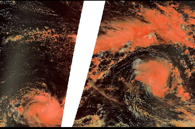
Alenga and Two-S not bothering anyone

Figure 1: Image of Tropical Storm Alenga (middle right) and Tropical Storm 02S (bottom left).

The first two tropical cyclones of the Southern Hemisphere tropical season have formed in the Southwest Indian Ocean region. Alenga gained a name yesterday and was destined to become a Category 2 equivalent cyclone. However shear and cooler waters prevented that and Alenga has now started to weaken. Alenga is a 50mph tropical cyclone and should move into the Australian region sometime tonight or tomorrow. It is unlikely that Alenga will survive long enough to impact Australia as a significant cyclone.

The other area of interest is our second tropical cyclone of the Southern Hemisphere: TC 02S. The Joint Typhoon Warning Center is observing this as a tropical storm, while Meteo France (MF) is only observing this as a tropical depression. The official forecast from JTWC keeps 02S steady at 40mph, while MF strengthens it to gain a name. The track for now is for the system to continue a westward movement until dissipation. The next name is Benilde.

Other than a worthless tropical depression that formed in the Western Pacific, the rest of the tropics have been quiet.

Matt

*Image credit to NASA

Saturday, November 26, 2011

Tropical Cyclone Five-A moving away from the coast of India

A new tropical cyclone over the Arabian Sea is causing havoc to portions of South India tonight. The cyclone has already caused three fishermen to go missing, as well as about 1500 homes in Sri Lanka being damaged. This system means business! Right now, the Joint Typhoon Warning Center is classifying this system as a tropical storm, however the India Meteorological Department is assessing this as a deep depression. This is why 05A has not gained a name yet. However, they continue to insist that this system will become a cyclonic storm thus gaining the name Thane. The JTWC also continues to insist that conditions will only be marginal for development, thus making strengthening difficult for the system. They only expect 05A to reach a peak of about 60mph.

An area of broad low pressure in the Southwest Indian Ocean continues to be stationary and struggle to develop. This system, designated 96S by the JTWC, has not moved in the past 12 hours. With vertical wind shear of about 30 knots impacting the system, mostly from the outflow of Tropical Cyclone 05A, any strengthening will be difficult. However, this system has shown signs of fighting for survival. The first name on the list is Alenga if it were to in fact to strengthen enough into such a storm.


Figure 1: Tropical Cyclone Five-A is shown to the west of India, and 96S is shown to the northeast of Madagascar.

That's all for today!
Matt

Wednesday, November 16, 2011

Possible late season activity for both basins?

Computer models are continuing to insist that we will have tropical storms in both basins by the end of the month. An area of disturbed weather (Invest 90E) has been designated in the Eastern Pacific and the National Hurricane Center is currently giving this system a low chance (10%) of developing in the next 48 hours. Tropical Storms this late in the season is very rare and there have only been 3 on record to have formed this late in the Eastern Pacific Hurricane Season: an unnamed tropical storm on November 27, 1951, Tropical Storm Sharon on November 27, 1971, and Hurricane Winnie on December 5, 1983. None of these storms affected land, and our potential Eastern Pacific Tropical Storm's track is uncertain.

Figure 1: My graphic on our newly formed Invest 90E.

In the Atlantic, the models are back on board with tropical/subtropical development northeast of the Atlantic. The origins would likely be non-tropical and the system would likely meander for a couple of days. This is similar to how Tropical Storm Sean developed.

So it's extremely possible that we get both Tropical Storm Kenneth (EPAC) and Tropical Storm Tammy (ATL) between now and next week. It's even possible that Kenneth could become a hurricane, if conditions improve for development.

Our first tropical disturbance of the 2011-12 South Pacific Season formed the other day and was extremely large in nature, almost monsoonal. This storm dumped a lot of rainfall on the island of Fiji. The Joint Typhoon Warning Center, at one time, gave this a Medium chance of development. However, the system was just too large, and wind shear was just too strong for this system to actually gain a name. We are in a La Niña event which typically means a more active season for both the South Pacific and the Australian Region. Activity is usually suppressed in the Southwest Indian Ocean during this event.

I'll have more updates as we learn more about our possible developments.
Matt

Friday, November 11, 2011

Sean merges with a front

Sean is now post-tropical as he has merged with a cold front. The National Hurricane Center has written their last advisory on the system. Bermuda did in fact get tropical storm force winds from Sean. Top winds were estimated to be around 45mph on the island. Sean indirectly caused one death in Florida due to rip currents.

Figure 1: Sean as it merged with a front.

There are no other areas to talk about currently, but the computer models are picking up on possible tropical development in the mid-Atlantic in about a week or so. They suspect a non-tropical low may gain some subtropical or tropical characteristics, similar to what happened with Sean. If any non-tropical low were to become subtropical, they name they would gain would be Tammy.

The other basins are quiet!
Matt

Thursday, November 10, 2011

Sean has peaked

Our only area of interest in the tropics today is Tropical Storm Sean. Sean has reached his peak as a 65mph tropical storm and should not be able to strengthen to a hurricane due to cooler waters. Bermuda is still under a Tropical Storm Warning due to Sean's wind field being extremely large. The forecast shows that Sean will become extratropical sometime in the next day or two.

Figure 1: Rainbow IR picture of Sean.

Figure 2: Projected Path of Sean

Some of the computer models are showing development in two different places. The GFS (American) Model has been off and on with subtropical development in the mid-Atlantic in about a week or so. Other models, like the NOGAPS and CMC, are forecasting development in the Southwestern Caribbean. These are typical hotspots for November, so I wouldn't completely write off the 2011 Atlantic Hurricane Season just yet.

The Eastern, Central, Western, and Southern Pacific Basins are quiet.

The North and Southwest Indian Ocean basins are quiet.

The Australian Region is quiet as well.

A short post for a boring day!
Matt

Wednesday, November 9, 2011

Sean almost a hurricane

Tropical Storm Sean has gradually gotten better organized today. Infrared and Visible Imagery show that an eye may be trying to form. This may be a sign that Sean may be close to hurricane strength. Winds are already close to it and only 9mph shy of becoming a Category 1 hurricane. We'll see what the next few days hold.

The projected path for Sean continues the motion to the north with a turn to the northeast sometime tomorrow. During that time, the National Hurricane Center thinks that Sean could reach minimal Category 1 strength but quickly weaken. Due to the large wind field of the system and the proximity to Bermuda, the Bermuda Weather Service has issued a Tropical Storm Warning for the island. If Sean becomes a stronger hurricane than expected, it wouldn't be out of the question that a Hurricane Watch or Warning be issued. However this seems highly unlikely at the moment.

Tropical Cyclone Four-A lost organization today and the Joint Typhoon Warning Center wrote their last advisory on the system.

The Australian Region and South Pacific basins are quiet today and there are no areas of concern.

The Southwest Indian Ocean Cyclone Season starts November 15.

That's all for today.
Matt